Goal: Working with and enhancing the natural features and resources of the site
p8.
The landscape and settlement character of South and Vale are varied and get their identity from natural settings and historical development. New development should respect and respond to this unique landscape character including its setting and views, share common characteristics with its locality and reinforce local identity, as well as providing well-designed landscapes.
p9.
The contextual analysis, including the constraints and opportunities plans, should be used to inform the layout of the site to ensure it works with and enhances the natural features and resources of the site.
p10.
The site layout should respect its physical features and those of its adjacent land including its landscape character, topography, orientation, landform, geology, drainage patterns, field patterns/boundaries and vegetation cover. You should use these resources positively in association with the physical features to benefit the intended users of your development and ensure that it does not have a negative impact on neighbouring land uses.
p11.
If a site is to be developed for renewable energy generation, the site contours and the extent of levelling and regrading works required to facilitate the development should be considered. This should be discussed as part of any pre-application and detailed within any planning application, based on topographical survey plans. Wherever possible such developments should utilise previously developed land, brownfield land, contaminated land, industrial land or agricultural land preferably of classification 3b, 4 or 5. When development is proposed on agricultural land it is desirable for the applicant to propose a project end date to demonstrate the temporary nature of the project.
p12.
Technical studies will show you whether there are any physical features that need protecting- this should include views, water features, existing vegetation, biodiversity or ecological value, heritage assets and setting. This technical information is needed to inform your design and support your application.
p13.
The site layout should include features that contribute to the green infrastructure, which can include existing features such as vegetation, water courses, areas of natural habitat and proposed features such as public open spaces, community orchards, structural planting, and Sustainable Drainage Systems (SuDS). Improving access to meaningful green spaces as well as their scale and quality is important for health and wellbeing.
Blue and green infrastructure network
Goal: Working with and enhancing the natural features and resources of the site
Ensure new features on the site such as public open spaces, street trees are linked into the existing blue and green network. Incorporate SuDS of various scales and types throughout the site to provide visually attractive features with wildlife value. Allow sufficient space to retain, incorporate and enhance existing habitats of wildlife value both green and blue.
Incorporate SuDS of various scales and types throughout the site to provide visually attractive features with wildlife value.
Allow sufficient space to retain, incorporate and enhance existing habitats of wildlife value.
This should also include formal play and informal recreation.
Open space
Goal: Working with and enhancing the natural features and resources of the site
Existing mature trees integrated into potential Public Open Space (POS) utilised to form dominant landscape feature. Highlight individual trees, retain existing trees on site within open spaces.
Woodland (onsite)
Goal: Working with and enhancing the natural features and resources of the site
Woodlands have elevated ecological value and can support a range of protected species. Many woodlands are priority habitats and benefit from increased protection in the planning system.
Development needs to be carefully planned to integrate woodlands appropriately. Root protection areas of trees should be protected, structures located where there is not likely to be any future arboricultural conflict and the ecological function of woodland edges safeguarded.
Woodlands can make valuable contributions to publicly accessible greenspace. Positive woodland management can enhance the ecological value of woodlands and make them more resilient to recreational pressures associated with development.
Retained woodlands will require a Woodland Management Plan including how they relate to the wider network of Public Open Space. Providing controlled access to retained woodlands (if appropriate) will reduce the pressure on more sensitive areas of woodland.
Green edges
Goal: Working with and enhancing the natural features and resources of the site
Create a green edge/ transitional landscape between new development and wider open countryside.
Woodland buffer
Goal: Working with and enhancing the natural features and resources of the site
Provide suitable buffer to woodland. A minimum of 15 meters for ancient woodland.
Retained hedgerows
Goal: Working with and enhancing the natural features and resources of the site
Hedgerows are important landscape and ecological features. Many species use hedgerows to move throughout the wider landscape.
Development should seek to retain the characteristic hedgerow pattern of a site and protect ‘important hedgerows’1
These linear site features could be used to form the basis of a green infrastructure network, supplemented with hedgerows, trees, and linked to offsite landscape hedgerow patterns.
Goal: Working with and enhancing the natural features and resources of the site
Assess impact of site on AONB and its setting.
Refer to AONB Management Plans, Character Assessments and Position Statements.
Consider Landscape Character of site and surroundings.
Refer to the hierarchy of Landscape Character Assessment.
Watercourse corridor
Goal: Working with and enhancing the natural features and resources of the site
Watercourses1form important blue (water environment) and green (terrestrial vegetation) corridors through the landscape. These corridors are vital for flood alleviation, biodiversity and are key landscape features.
Development should respect watercourse corridors and provide a buffer of at least 10 metres from the top of either side of the bank. Watercourse buffer zones should be managed to enhance the ecological function of the corridor.
Goal: Working with and enhancing the natural features and resources of the sites
Ancient woodland is of prime ecological, landscape and heritage value. These areas have been continuously wooded since at least 1600AD, but many are much older. It is not possible to recreate ancient woodland once it is lost. This is why ancient woodland is identified as an irreplaceable habitat.
Ancient woodland benefits from strict protection in the planning system. Standing advice1 requires that development is buffered from ancient woodland by a minimum of 15 metres. Larger developments will require buffers greater than 15 metres. Buffers help to avoid direct and indirect impacts of development on the ancient woodland.
Careful consideration should be given to the protection of ancient woodland areas when planning a development. Public access may need to be limited or restricted altogether. Buffers should be acknowledged in the masterplan and managed to bolster the green infrastructure of the site. It is not appropriate to have private gardens within ancient woodland buffers.
Development, including construction and operational activities can affect ancient woodland, having both direct and indirect effects. Effects to consider include:
changes to woodland and tree habitat, including understory, ground flora and roots;
changes to functional habitat connections;
changes to air quality, such as traffic and other pollution;
changes to ground water, from pollutants or changes in hydrology;
increased light pollution;
increased noise and vibration;
damage to archaeological features or heritage assets;
changes to landscape character
risk of garden encroachment, including potential invasive
species;
risk of damage to people and property by falling branches or trees requiring tree management that could cause habitat deterioration.
Goal: Working with and enhancing the natural features and resources of the sites
Assess the impact of proposed development on the adjacent Landscape Character, its setting and views.
Refer to the hierarchy of Landscape Character Assessment including the AONB Management Plans, Character Assessments and Position Statements where applicable.
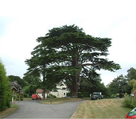
Existing trees and tree groups
Goal: Working with and enhancing the natural features and resources of the sites
Individual trees and tree groups support biodiversity and make important contributions to the character and visual amenity of a site.
Integrating established trees can add instant maturity to developed areas and provide a range of benefits, including shading, noise alleviation and improving air quality.
Existing mature trees should be integrated into Public Open Space (POS) rather than garden spaces to aid their protection and add instant maturity to a development.
Development should avoid root protection areas of trees to be retained and sufficient space should be designed in the development for the canopies of trees to naturally develop. Buildings and structures should be located sufficient distance away from tree canopies, so a harmonious future relationship exists, that can be sustained in the long term.
Please be aware trees might be protected by a Tree Preservation Order or where they are located within a conservation area.
A check can be made on the Trees section of the Council’s website:
Veteran and ancient trees are identified due to their age, size or condition and are of exceptional biodiversity, landscape and heritage value. Very few trees ever reach the ancient life-stage. Similar to ancient woodland, veteran and ancient trees are irreplaceable habitats and benefit from strict protection in the planning system.1
All trees that are ancient are also veteran trees. However, not all veteran trees are identified as being ancient. The age at which a tree develops into an ancient or veteran stage will vary between species.
Veteran and ancient trees should be buffered from development by at least 15 times the stem diameter, or 5 metres greater than the widest part of the canopy; whichever is larger.
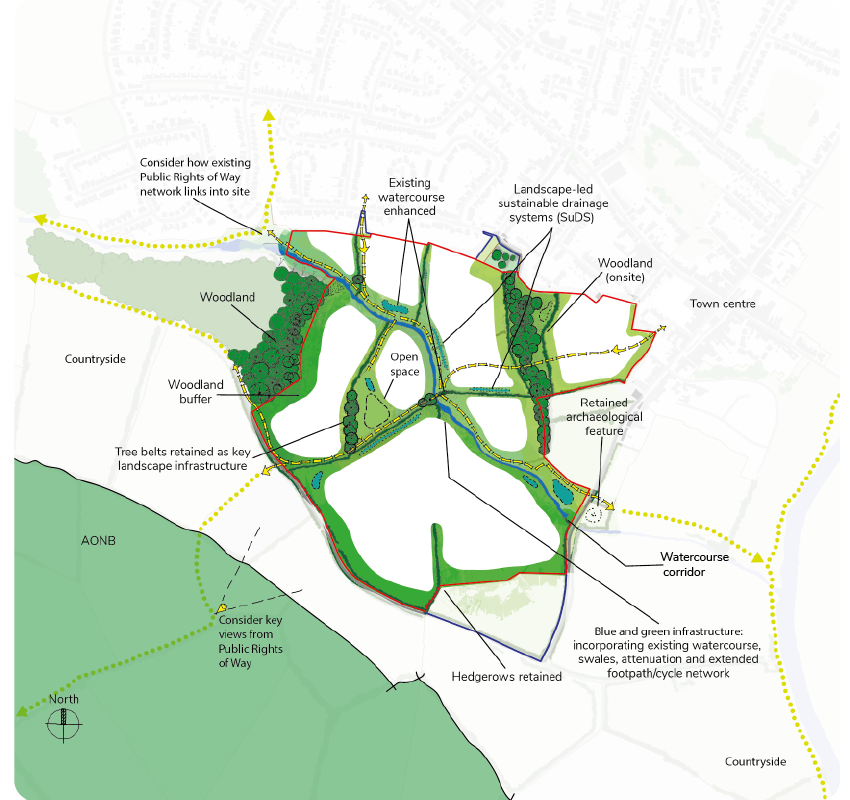
Figure 3:
Identify, retain, and enhance the green infrastructure and natural features as part of a scheme (major example)
Figure 3: Identify, retain and enhance the green infrastructure and natural features as part of a scheme (major example)
Open space
Goal: Working with and enhancing the natural features and resources of the site
Existing mature trees integrated into potential Public Open Space (POS) utilised to form dominant landscape feature.
Highlight individual trees, retain existing trees on site within open spaces.
Blue and Green corridors
Goal: Working with and enhancing the natural features and resources of the site
Blue and Green corridor with additional landscaping joining up a series of green features and providing extra green connections.
Incorporate SuDS of various scales and types throughout the site to provide visually attractive features with wildlife value.
Allow sufficient space to retain, incorporate and enhance existing habitats of wildlife value.
This should also include formal play and informal recreation.
Green edges
Goal: Working with and enhancing the natural features and resources of the site
Create a green edge/ transitional landscape between new development and wider open countryside
Retain hedgerows
Goal: Working with and enhancing the natural features and resources of the site
Retain characteristic hedgerow pattern where possible and Important Hedgerows. Use to form basis of green infrastructure network.
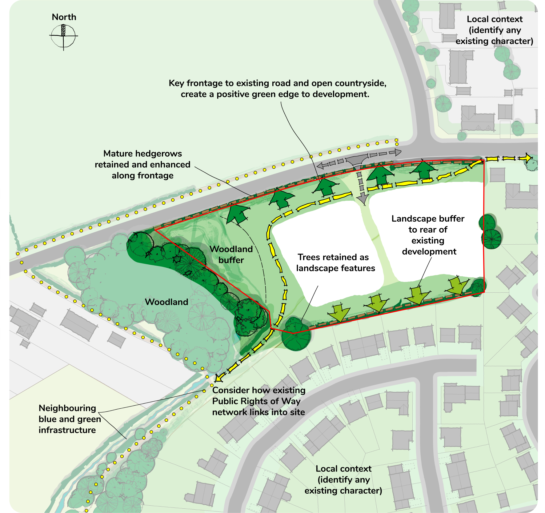
Figure 3a:
Identify, retain, and enhance the green infrastructure and natural features as part of a scheme (minor example)
Figure 3a: Identify, retain and enhance the green infrastructure and natural features as part of a scheme (minor example)
Steps
Inform your design:
Provide technical studies including (but not limited to) surveys on trees, habitats, species, biodiversity metric assessment, landscape character and visual assessment/appraisal, historic appraisals, etc.
Communicate your design:
Prepare a Landscape Strategy that sets out the development’s landscape including details on how the existing landscape and biodiversity features will be retained and incorporated into the site layout and the intended function and management of proposed features (e.g. how high are the hedges allowed to grow?);
Demonstrate how the features of Sustainable Drainage Systems (SuDS), e.g. retaining ponds and swales will be integrated into the development’s landscape.
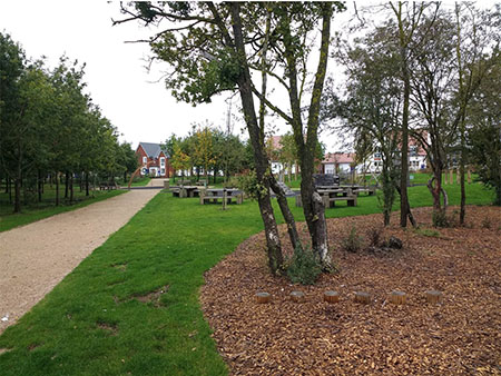
Tree planting in public square (Abingdon)Tree lined streets and formal planting (Milton Park)Clusters of trees planted in public open space (Tadpole Garden Village)High value trees incorporated into open space (Aston Rowant)
Design principles - Natural Environment
Ensure the scheme:
retains and strengthens the site’s landscape features; using the physical features of the site and results of technical studies positively and imaginatively in its design:
A Landscape and Visual Impact Assessment or Landscape and Visual Appraisal is undertaken, appropriate to the scale and the sensitivity of the site as set out in Guidelines for Landscape and Visual Impact Assessment (GLVIA);
Reference should be made to any relevant national, county, district, and neighbourhood Landscape Character Assessments and how the site conforms to or differs from these. The particular character of the site and immediate surroundings should be recorded to pick up other characteristics that may be important in considering the effects and the design of the proposal;
The Landscape and Visual Assessment work should be used to inform the design of the development, so that possible effects are identified at the outset and design responses have been implemented as an integral part of a scheme, such as modifications to siting, access, layout, buildings, structures, ground modelling and planting;
The North Wessex Downs and the Chilterns Areas of Outstanding Natural Beauty (AONB) cover large areas of land within the districts. Their Management Plans and associated documents should be applied to any proposals within the AONB or their setting.
retains and creates views in and out of the site to prominent landscape features and landmarks;
is designed to maximise the benefits of natural resources (utilising landform, orientation, geology, and natural drainage patterns) and does not negatively impact on the benefits enjoyed by neighbouring properties and spaces;
implements SuDs (Sustainable Drainage Systems) as an integral part of the development’s open space network. SuDs should be designed into the development from the outset with features such as: wetlands, basins, ponds, scrapes, swales, retention planters (rainwater gardens), combined with good landscaping to make a positive contribution to the biodiversity, character and appearance of a development;**
creatively integrates and enhances historic landscapes (such as agricultural patterns or historic battlefields) and the survival of archaeological remains and features (refer to Historic England scheduling selection guide);
has a joined-up network of open spaces which form an integral part of the development and are located where existing and new residents can access them easily, not just located on the edge of the development (or where there is left over space) and must be useable;**
provides a variety of natural and designed landscapes for everyone, that is accessible, with different functions to suit a diverse range of needs;**
does not use landscape as a barrier between new and existing development and is therefore integrated into the settlement (unless there is strong justification to create a landscape buffer, for instance to reduce the impact of road/rail noise, to retain gaps between settlements or link open spaces);
identifies noise, smells, air quality and contaminated land sources (e.g. sewage treatment works, railway line, a ring road, etc.) to inform the orientation and location of a development and responds to it positively. If land is not suitable for development due to amenity issues, play space and most public open space should not be located in these areas.
Note: All design principles are applicable to all scales of development unless otherwise specified; *minor applications, **major applications