The two districts are protected by numerous areas of special designation. These include Areas of Outstanding Natural Beauty (AONB), Green Belt land, listed buildings and conservation areas, which seek to preserve the districts natural and built environment for future generations.
The map below illustrates the locations of these designations across the two districts and provides further information about them. The map should not be viewed as definitive, and applicants should carry out their own analysis or refer to the public Geographics Information System (GIS) database provided by South Oxfordshire and the Vale for further details.
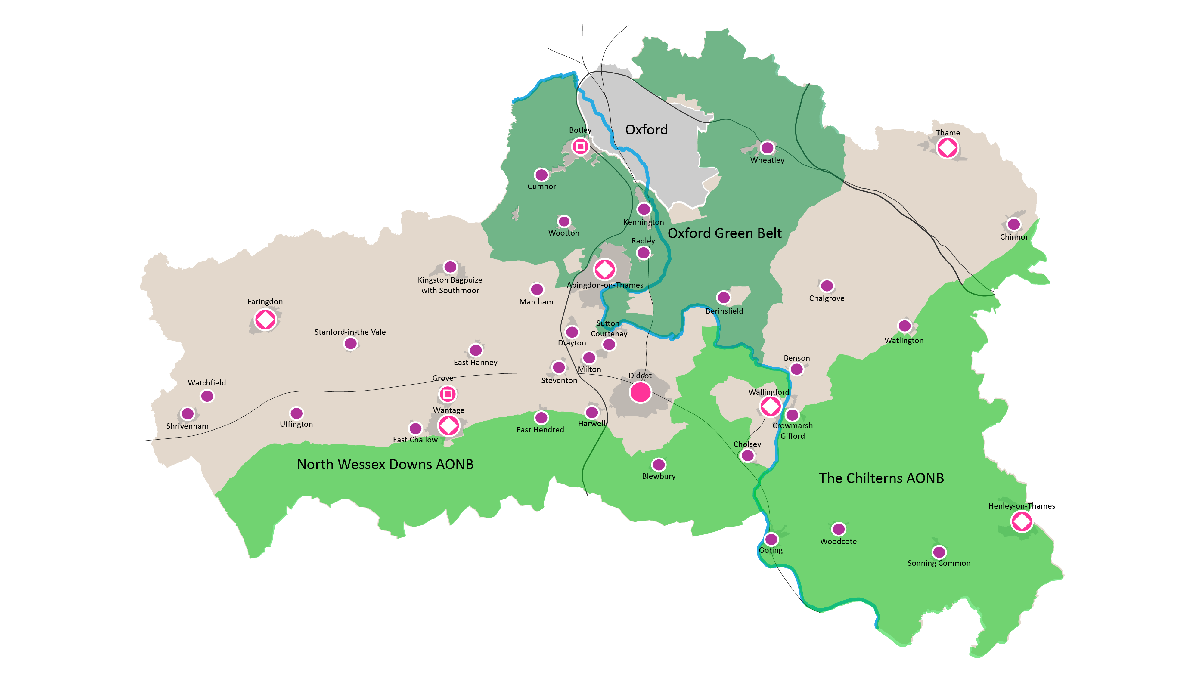
Settlements and designations map for South Oxfordshire and the Vale
Key:
The Oxford Green Belt
Goal: Identify the site’s settlements and designations
In common with all other Green Belts, the primary planning purpose of the Oxford Green Belt is to prevent urban sprawl into the countryside and the coalescence of settlements. It is also intended to protect the setting of the historic City and to encourage the re-use of derelict land (brownfield sites) within it. It also serves as an opportunity for city dwellers to have ready access to the countryside. (The five purposes of Green Belts are set out in section 1.5 of Planning Policy Guidance 2: Green Belts)
In planning terms, the quality and nature of the land within a Green Belt is irrelevant.
Agriculture is an important aspect of this Green Belt. The proportions of land registered as being in agricultural use and taken up by Agri-Environment schemes aimed at promoting more environmentally sustainable land management, are also higher than the national average.
There are important resources in terms of a dense public rights of way network. This Green Belt has proportionally more land at risk of flooding than any other Green Belt (6920 hectares or 20% of the land area).
Goal: Identify the site’s settlements and designations
The Chilterns is a belt of high ground stretching from the River Thames at Goring in Oxfordshire, north-eastward through Buckinghamshire and Bedfordshire and into Hertfordshire, where it almost reaches Hitchin. It is fringed by substantial settlements, including Luton, Dunstable, Hemel Hempstead, Berkhamsted, Chesham, Amersham, Beaconsfield, High Wycombe, Marlow, Henley-on-Thames and Reading. The hills are formed by an outcrop of chalk on the north-western side of the London basin. The chalk strata have been tilted to create a dip-slope that rises so gently to the north-west that it generally has the character of a plateau.
However, it ends abruptly in a steep scarp slope, which forms the more dramatic north-western face of the Chilterns. The plateau is cut by a series of through valleys that divide it into roughly rectangular blocks, with many branching dry valleys further dividing these blocks, to create a varied mix of landscapes.
The most notable feature of the characteristic vernacular buildings in the AONB, both in villages and elsewhere, is the consistent use of materials, especially the flints that occur in both the chalk strata and the overlying clay with flints. Flint is often combined with brick, both in the walls of older buildings and in boundary walls around gardens. Most vernacular buildings also have tiled roofs, with the tiles often having been made from local iron clay. Thatch appears relatively infrequently, with notable concentrations in the northern and southern extremities of the AONB.
Goal: Identify the site’s settlements and designations
Areas of Outstanding Natural Beauty (AONBs) are designated by the Government for the purpose of ensuring that the special qualities of our finest landscapes are conserved and enhanced. In planning policy terms, they have the same status as National Parks.
The primary purpose of the AONB is to conserve and enhance the natural beauty of the AONB. The AONB also has secondary purposes to increase awareness and understanding of the special qualities of the AONB, to take account of the needs of agriculture, forestry and other rural industries and to foster the social and economic wellbeing of local communities and those who live and work in the area.
The setting of the AONB does not have a defined geographical boundary but it should be addressed as the area within which development and land management proposals, by virtue of their nature, size, scale, siting, materials or design can be considered to have an impact, either positive or negative, on the natural beauty and special qualities of the AONB.
The surroundings of the AONB and the protected landscape of the AONB add value to each other as the landscape and landforms link visually and functionally, joining the surroundings to the AONB. Proposals for change in the setting should, therefore, have regard to the inter-relationship with the AONB and the landscape character and special qualities.
The North Wessex Downs is a visibly ancient landscape of great beauty, diversity and size. It embraces the high, open arable sweeps of the chalk downs and dramatic scarp slopes with their prehistoric monuments and beech knolls, the moulded dip slopes, sheltered chalk river valleys, intimate and secluded wooded areas and low-lying heaths with a rich mosaic of woodland, pasture, heath and commons. The North Wessex Downs AONB forms a surprisingly remote, expansive and tranquil landscape in the heart of southern England.
The designation of Area of Outstanding Natural Beauty recognises the character, value and quality of the North Wessex Downs. Although almost entirely a chalk landscape, the North Wessex Downs’ character differs markedly across the area, depending on local surface geology, soils, landform, land use, vegetation and settlement patterns. The greatest contrast, for example, is between the open arable chalk downs and the acid heathlands of the lower river valleys
The depth of history can still be seen in these landscapes, including the Uffington White Horse, and the Ridgeway – the oldest road in England. The built environment makes a strong contribution to the beauty of the landscape, with historic towns and villages, churches, spectacular barns and manor houses with their parks and gardens. The Saxon name of Wessex reveals the area’s literary connections, revived by Thomas Hardy and used as the setting for many of his novels. Around a century later, Richard Adams provided a vivid evocation of this area in ‘Watership Down’.